") | |||||||||||
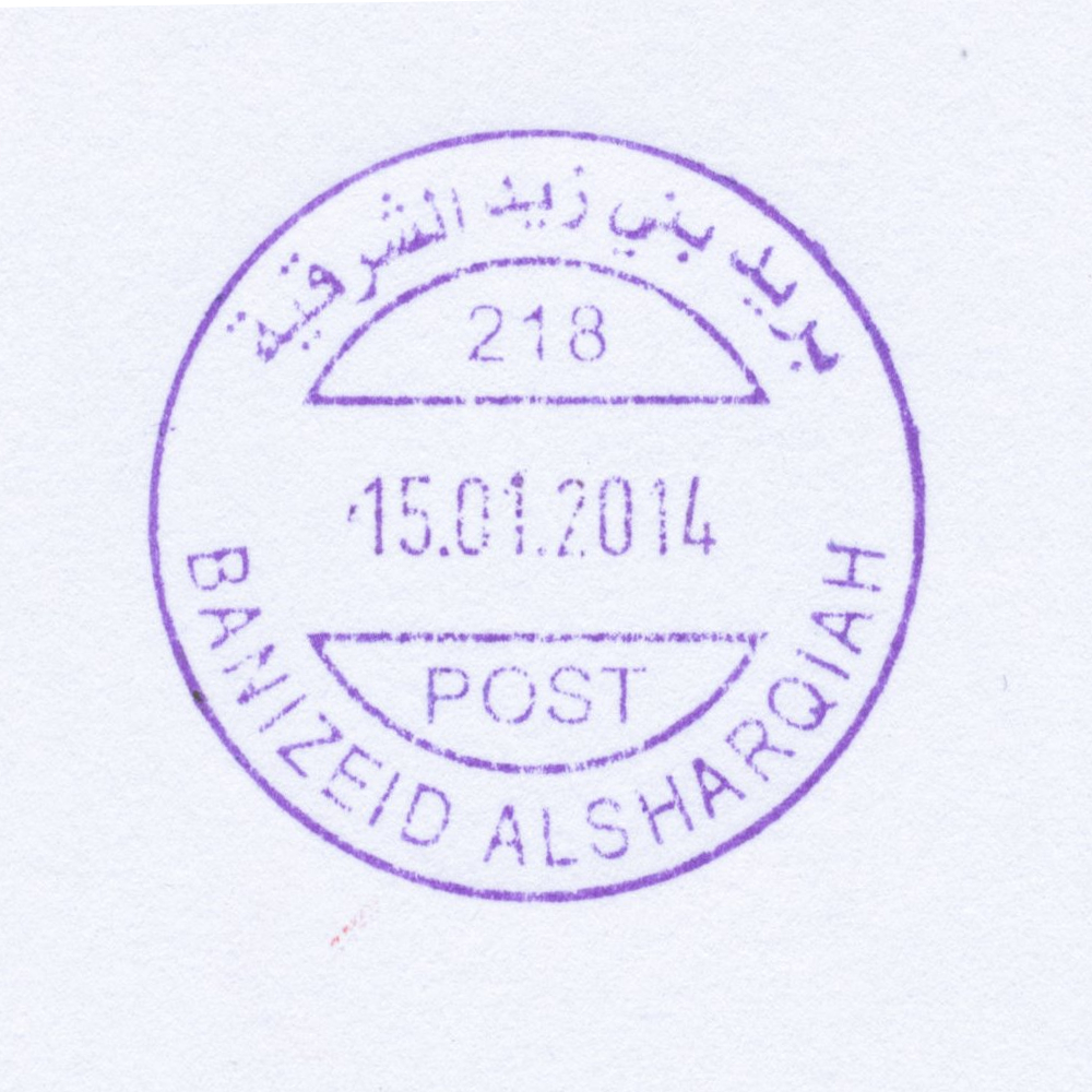
 Bani Zeid ash Sharqiya © OpenStreetMap contributors, CC-BY-SA") | Bani Zeid ash Sharqiya بني زيد الشرقية Bani Zeid al-Sharqiya ('Arura, Mazari al-Nubani), Bani Zaid Alsharqiyah, Bani Zeid al-Sharqia | Pop.: 5,083 Govern.: Ram Opened: 2009 PO Number: 215 Postcode: 660 | |||||||||
| 32°03' N, 35°10' E OpenStreetMap Google Maps Wikipedia | Town in Ramallah Governorate, 4 km S of Salfit and 20 km N of Ramallah. The municipality was created in 2005 by the merger of villages 'Arura and Mazari al-Nubani with a population of 5,083 (Census 2007, 1997: 3,863, 1945: 1,750). Jordanian authorities operated a postal agency in 'Arura between 13.01.1966 and 4.06.1967. The PNA office, is on Masqat Street, next to Masqat health centre in 'Arura; nearest other offices are Bani Zeid al-Gharbiyeh to the W, Abwein to the E, and Bir Zeit to the S. | ||||||||||
| |||||||||||
 banizeidalsharqia218_140115_0505")
") | |||||||||||
") ") | |||||||||||
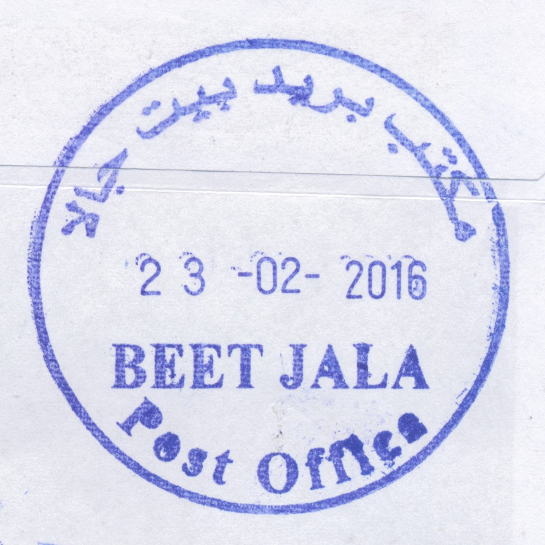
 Beit Jala © OpenStreetMap contributors, CC-BY-SA") | Beit Jala بيت جالا Beit Jala | Pop.: 11,758 Govern.: Bet Opened: 1910 PO Number: 502 Postcode: 160 | |||||||||
| 31°43' N, 35°11' E OpenStreetMap Google Maps Wikipedia | Largely christian town just NW of Bethlehem, about 10 km S of Jerusalem, with some 12,000 inhabitants (1997 Census: 11,957, 2007 Census: 11,758. Nearest other office is Bethlehem. An Egyptian office worked between 24.12.1948 and (?)## .Jordanian authorities operated a post office between 1949(?) and 5.06.1967. A post office under control of the Israeli military occupation forces existed from 23.08.1967. The PNA post office is on Tujjar street. | ||||||||||
| |||||||||||
 beetjalaPO_160223_0503")
| |||||||||||||||
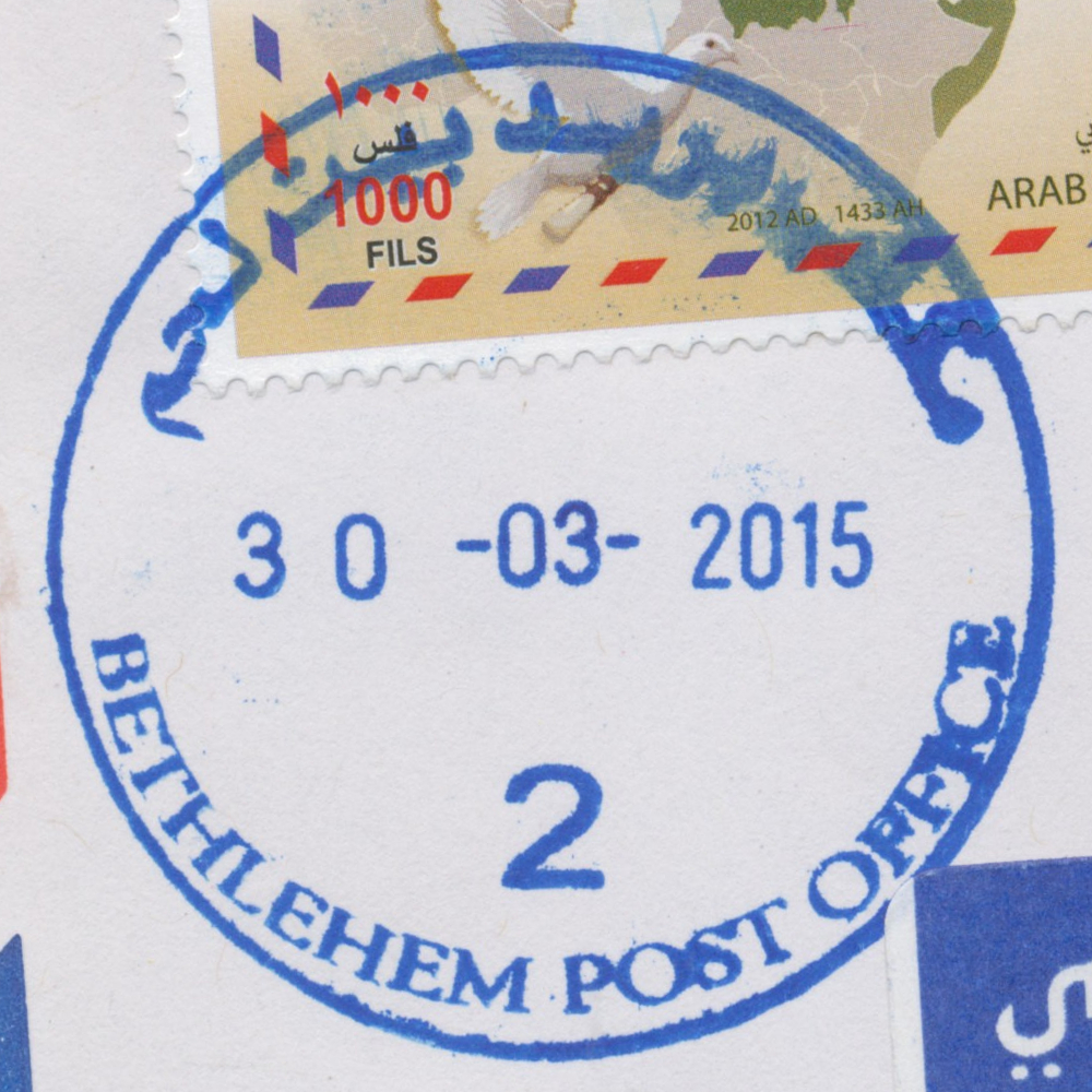
 Bethlehem © OpenStreetMap contributors, CC-BY-SA") | Bethlehem بيت لحم Beth Lehem, Beit Lahm | Pop.: 25,266 Govern.: Bet Opened: 1870 PO Number: 501 Postcode: 150 | |||||||||||||
| 31°42' N, 35°12' E OpenStreetMap Google Maps Wikipedia | Governorate capital with 25,266 inhabitants (Census 2007, 1997: 21,673) and a large Christian minority, dominated by tourism and trading. The post office is inbetween the municpal offices and Cairo-Amman Bank on the west side of Manger Square. The first post office in the city was opened by the Ottoaman authorities in 1870. An Egyptian office worked between 10.06.1948 and 11.10.1948. Jordanian authorities operated a post office (district main PO) between November 1948(exact date?) and 5.06.1967. A post office under control of the Israeli military occupation forces existed from 10.07.1967. | ||||||||||||||
| |||||||||||||||
 2006")
 2008")
 2008")
 April 2010")
 April 2010")
")
")
")
")

 bethlPO2_150330_0498")
") | |||||||||||
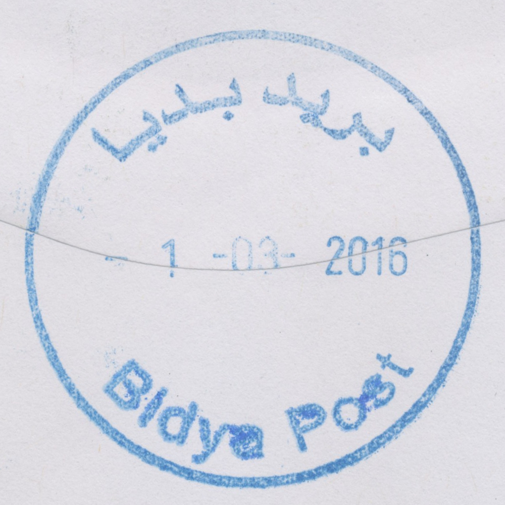
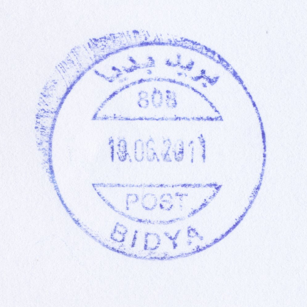
 Bidya © OpenStreetMap contributors, CC-BY-SA") | Bidya بديا Bedia, Biddya, Biddia | Pop.: 8,064 Govern.: Sal Opened: 27.05.1995 PO Number: 808 Postcode: 380 | |||||||||
| 32°07' N, 35°05' E OpenStreetMap Google Maps Wikipedia | The second largest city of Salfit Governorate with 8,064 (Census 2007, 1997: 6,058) residents; about 10 km NW of Salfit and 13 km SW of Nablus. Nearest other post offices are Bruqin to the S, Kafr Thulth and Azun to the N, Kufel Haris and Deir Istiya to the E. Jordanian authorities operated a postal agency from 16.10.1963. | ||||||||||
| |||||||||||
| |||||||||||
 bidyaP_160301_0502")
 bidya808_110819_0506")
") | |||||||||||
 | |||||||||||
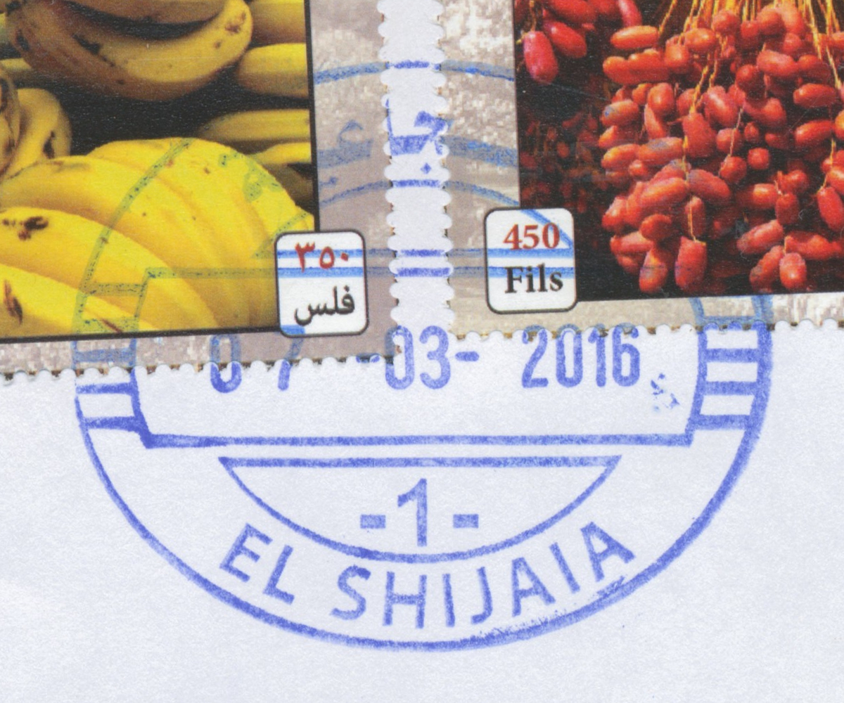
 Gaza, El Shijaia © OpenStreetMap contributors, CC-BY-SA") | Gaza, El Shijaia غزة - الشجاعية Gaza, Gaza El Shijaia, Gaza Al Shuja'iyeh | Pop.: ,n/a Govern.: Gaz Opened: 1865 Postcode: 860 | |||||||||
| 31°30' N, 34°28' E OpenStreetMap Google Maps Wikipedia | El-Shijaia is just E of Gaza Old City, where the first post office was opened in 1865 by the Ottoman authorities. An Egyptian office operated here from 1948--1967. A post office under control of the Israeli military occupation forces existed from 13.07.1967. The current office is situated near the corner of al-Wehda and Salah al-Din streets, opposite the local police station. | ||||||||||
| |||||||||||
 gazashijaia1_160307_0504")
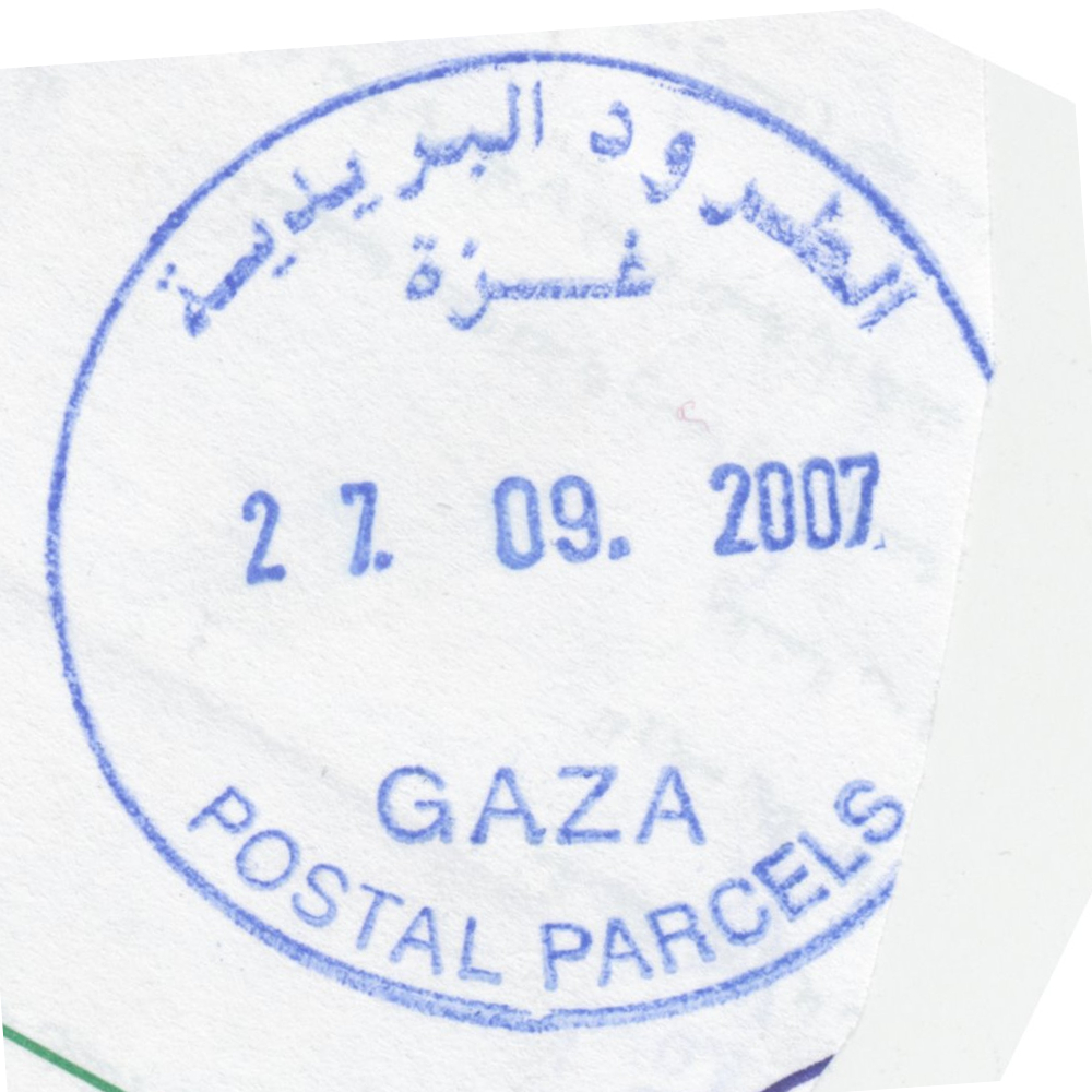
 Gaza, Central Sorting © OpenStreetMap contributors, CC-BY-SA") | Gaza, Central Sorting غزة - الفرزالمركزي Gaza, Central Sorting | Pop.: n/a Govern.: Gaz Opened: - Postcode: 860 | |||||||||
| 31°33' N, 34°27' E OpenStreetMap Google Maps Wikipedia | Central sorting facilty, situated in the Omar al-Mukhtar office. | ||||||||||
| |||||||||||
 gazapparcels_070927_0508")
") ") | |||||||||||
") ") | |||||||||||
 Gaza, Omer El Mokhtar © OpenStreetMap contributors, CC-BY-SA") | Gaza, Omer El Mokhtar غزة - عمرالمختار Gaza, Omer El Mokhtar, Omar El Mokhtar | Pop.: 409680 Govern.: Gaz Opened: 17.10.1996 PO Number: 909 Postcode: 850 | |||||||||
| 31°33' N, 34°27' E OpenStreetMap Google Maps Wikipedia | Governorate capital with a population of 409,680 (2006 mid-yearestimate). The first post office was opened in 1865 by the Ottoman authorities. A post office (New Gaza 5) under control of the Israeli military occupation forces existed from 9.04.1968. The city's main post office is in the MTIT building on Omar al-Mukhtar Street between Abu Khadra mosque and the municipal park. From 4.11.2012, the office moved temporaily to the Government Computer Complex building Abu Khadra. The PO was re-opened on 12.02.2013 with an official ceremony on 26.02.2013 (5.03.2013?). | ||||||||||
| |||||||||||
 gazaOmar_141229_0500")
 Jayyus © OpenStreetMap contributors, CC-BY-SA") | Jayyus جيوس Jayyous | Pop.: 2,894 Govern.: Qal Opened: 2004 PO Number: 819 Postcode: 353 | |||||||||
| 31°12' N, 35°02' E OpenStreetMap Google Maps Wikipedia | Agricultual village in Qalqilya Governorate, about 6 km E of the muhfaza. Population: 2,894 (Census 2007, 1997: 2,349). Nearest other office is Azun to the S. Jordanian authorities operated a postal agency from 8.11.1965. | ||||||||||
| |||||||||||
 jayyusP_150311_0509")
| |||||||||||
") | |||||||||||
 | |||||||||||
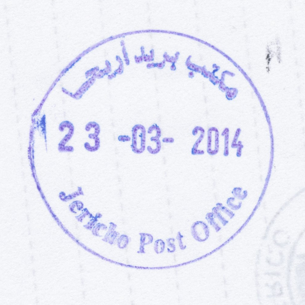
 Jericho © OpenStreetMap contributors, CC-BY-SA") | Jericho أريحا Jericho (Ariha) | Pop.: 18,346 Govern.: Ari Opened: 1900 PO Number: 601 Postcode: 580 | |||||||||
| 31°51' N, 35°27' E OpenStreetMap Google Maps Wikipedia | Ancient city, 258 metres below sea level, one of the oldest and continuously inhabited places in the world, hence the postmark inscription "the oldest city in the world". Muhfaza (seat) of the PNA governorate. The city's population was 18,346 (Census 2007, 1997: 14,674) though the office serves practically the entire governorate's population of over 42,000. An Ottoman post office was first opened in 1900, the PNA office is on Amman street (Kramah st) just off Palestine Square (PalTel/Ministry of Communication building). Jordanian authorities operated a post office (district main PO) between 1948(? - EKP: 18.04.1949) and 6.06.1967. A post office under control of the Israeli military occupation forces existed from 12.07.1967. | ||||||||||
| |||||||||||
")
 April 2010")
 April 2010")
 jerichoPO_140323_0510")
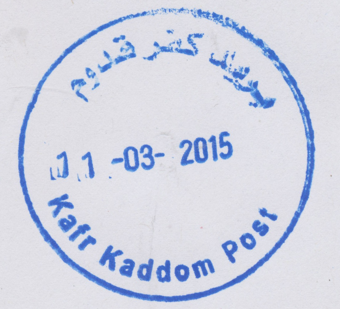
 Kafr Kaddom © OpenStreetMap contributors, CC-BY-SA") | Kafr Kaddom كفرقدوم Kefer Qaddom, Kafr Qaddum | Pop.: 2,908 Govern.: Qal Opened: 11.03.2003 PO Number: 812 Postcode: 370 | |||||||||
| 32°13' N, 35°09' E OpenStreetMap Google Maps Wikipedia | Village in Qalqilya Governorate, 16 km E of the muhfaza and 10 km W of Nablus. Popululation stans at 2,908 (Census 2007, 1997: 2,481). Surrounding offices are in Beit Lid, Deir Istiya, Azun, and Jayyus. Jordanian authorities operated a postal agency from 13.06.1963. | ||||||||||
| |||||||||||
 kafrkaddom_150311_0497")
") ") | |||||||||||
") | |||||||||||
 | |||||||||||
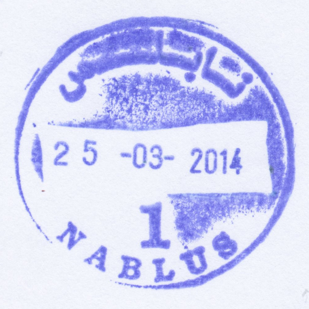
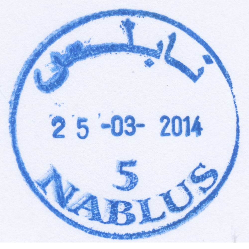
 Nablus © OpenStreetMap contributors, CC-BY-SA") | Nablus نابلس Nablus | Pop.: 126,132 Govern.: Nab Opened: 13.02.1865 PO Number: 301 Postcode: 400 | |||||||||
| 32°13' N, 35°16' E OpenStreetMap Google Maps Wikipedia | Governorate capital with 126,132 inhabitants (Census 2007, 1997: 100,034). The first post office in the city was operned in 1865 by the Ottoman authorities. Jordanian authorities operated a post office (district main PO) from (?)##. A post office under control of the Israeli military occupation forces existed from 13.07.1967, a 'Nablus Market Branch' (pmk: 'Nablus 3') opened 16.06.1971 but closed 31.03.1973. The current main office is on King Faisal road, next to PalTel and municipal offices. | ||||||||||
| |||||||||||
| |||||||||||
| |||||||||||
 nablus1_140325_0511")
 nablus2_140325_0512")
 nablus5_140325_0513")
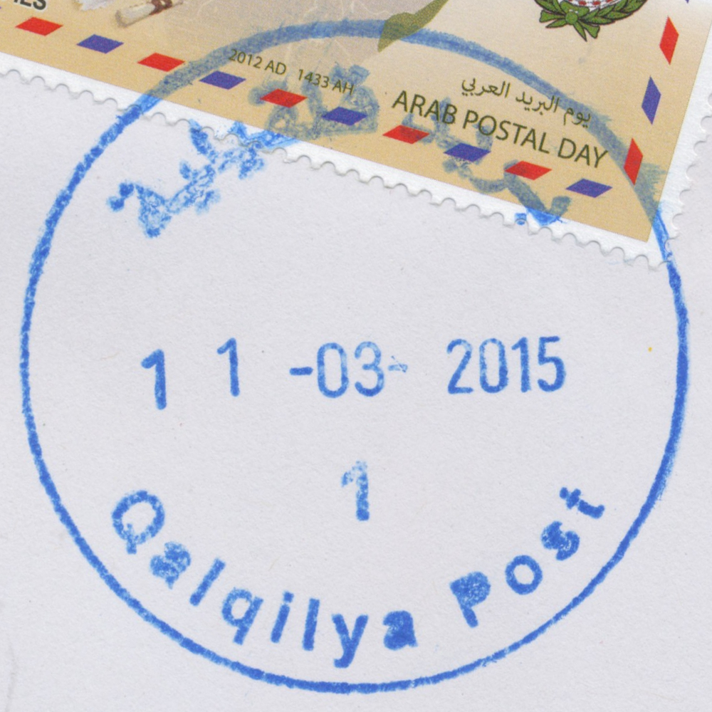
 Qalqilya © OpenStreetMap contributors, CC-BY-SA") | Qalqilya قلقيلية Qalqilia, Qalqiliya, Qulqilya, Qalqilyah | Pop.: 41,739 Govern.: Qal Opened: 1951 PO Number: 802 Postcode: 340 | |||||||||
| 32°11' N, 34°58' E OpenStreetMap Google Maps Wikipedia | Governorate muhfaza with 41,729 residents in 2007 (1997: 31,753) almost entrirely surrounded by the Apartheid Wall. The office is in the Nazzal neighbourhood near al-Quds Open University's study center on Nablus street. Jordanian authorities operated a post office from 1951. A post office under control of the Israeli military occupation forces existed from 21.08.1967. | ||||||||||
| |||||||||||
 qalqilyaP1_150311_0495")
 Rafah, Terminal © OpenStreetMap contributors, CC-BY-SA") | Rafah, Terminal عبور رفح Rafah, Terminal Rafah, Al Awda Crossing, Alawda Crossing, Rafah Crossing | Pop.: n/a Govern.: Raf Opened: 1.10.1995 Postcode: 980 | |||||||||
| 31°15' N, 34°16' E OpenStreetMap Google Maps Wikipedia | Border office at the Rafah Crossing, serving travellers to and from Egypt. First opened in 1995. A planned post office in the nearby airport has apparently never operated. | ||||||||||
| |||||||||||
 rafahterminal1_131120_0514")
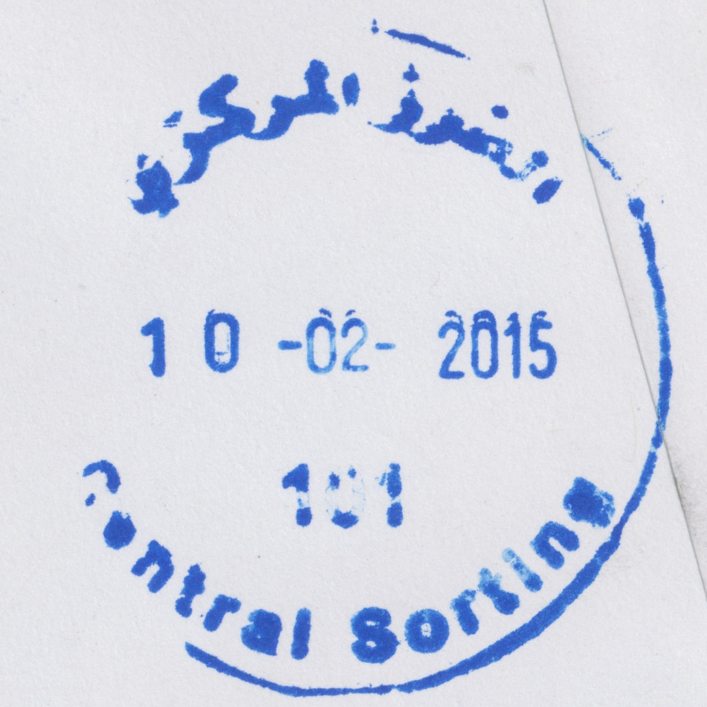
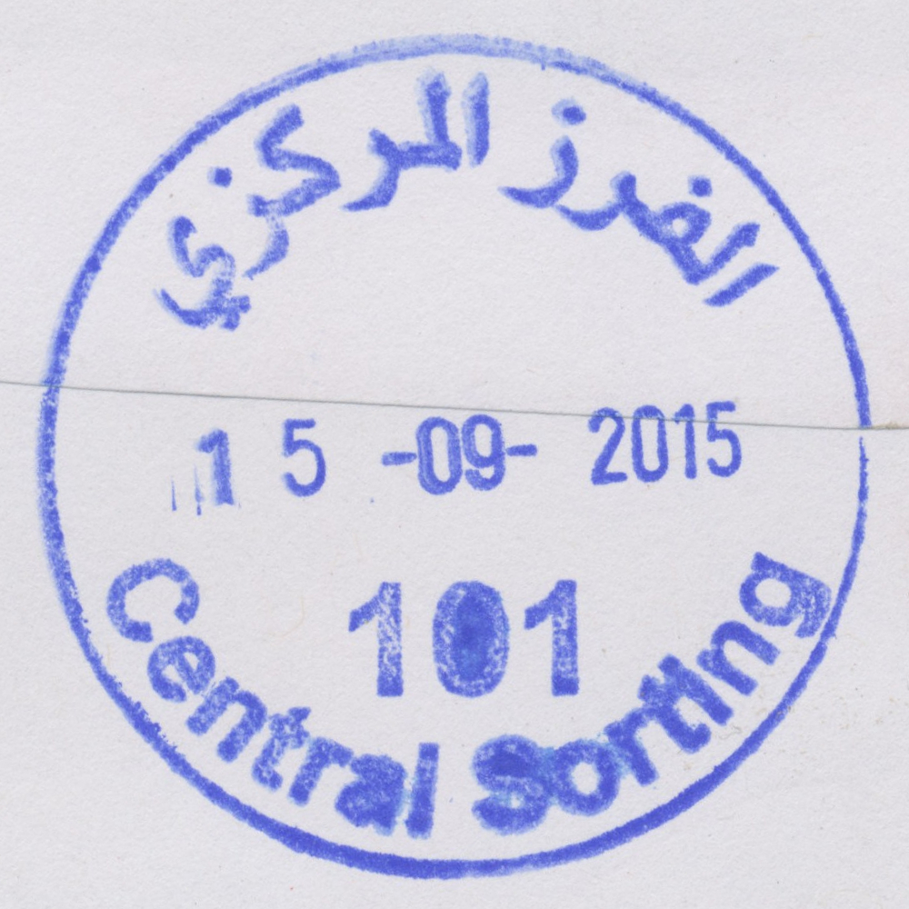
 Ramallah, Central Sorting © OpenStreetMap contributors, CC-BY-SA") | Ramallah, Central Sorting الفرز المركزي Ramallah, Central Sorting | Pop.: n/a Govern.: Ram Opened: 1997 PO Number: 101 Postcode: 600 | |||||||||
| 31°54' N, 35°13' E OpenStreetMap Google Maps Wikipedia | Central sorting facilty in the Directorate General, al-Muntazah street, in al-Bireh. | ||||||||||
| |||||||||||
| |||||||||||
 censort101_150210_0507")
 censort101_150915_0499")
 April 2010") | |||||||||||
") ") | |||||||||||
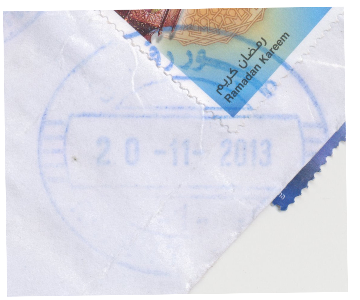
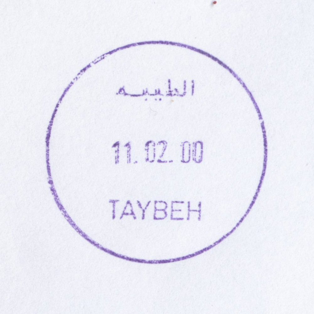
 Al Taybeh © OpenStreetMap contributors, CC-BY-SA") | Al Taybeh الطيبة Al Taiba, Ataybeh, At Tayba | Pop.: 1,452 Govern.: Ram Opened: 6.03.1960 PO Number: 207 Postcode: 464 | |||||||||
| 31°57' N, 35°18' E OpenStreetMap Google Maps Wikipedia | Christian village 11 km NE of the Ramallah/al-Bireh conurbation with only 1,452 inhabitants (2007 Census, 1997: 1,496). Jordanian authorities operated a post office (upgraded from a postal agency on 4.09.1965) between 6.03.1960 and 5.06.1967. A new building was erected in 2009 on the main road just N of al-Lateen church. Silwad is 3 km to the W, with al-Mazra aesh-Sharqiya further to the N and Deir Debwan to the S. | ||||||||||
| |||||||||||
 taybeh_000211_0516")
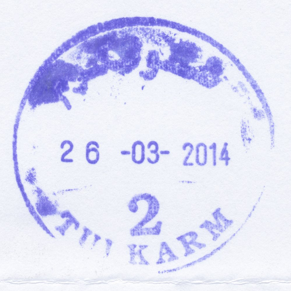
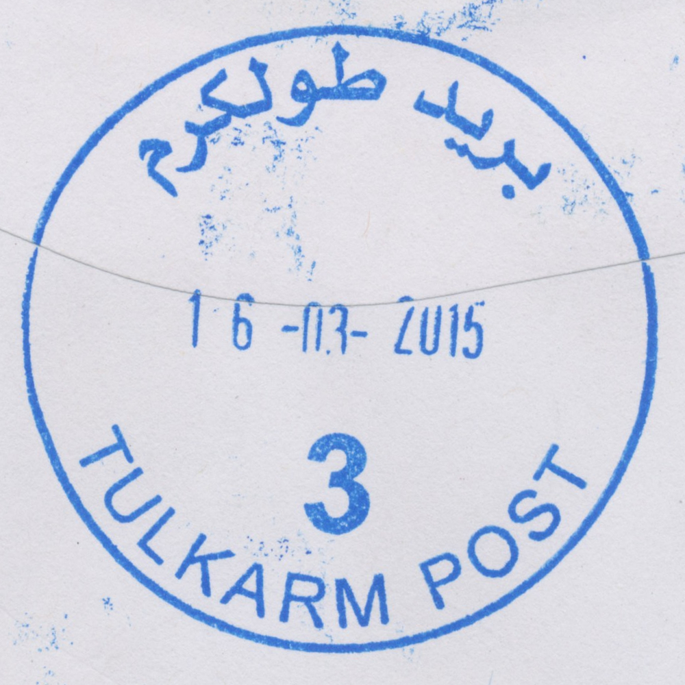
 Tulkarm © OpenStreetMap contributors, CC-BY-SA") | Tulkarm طولكرم Toolkerem, Tulkarem, Tul-Karm, Tul Qarem | Pop.: 21,300 Govern.: Tul Opened: 1906 PO Number: 801 Postcode: 300 | |||||||||
| 32°19' N, 35°02' E OpenStreetMap Google Maps Wikipedia | Governorate capital with (when including Tulkarm Camp & Dhinnaba) a population of 61,941 (Census 2007, 1997: 50,293), directly on the Green Line and now almost entirely surrounded by the Apatheid Wall. The first post office in the city opened under Ottoman rule in 1906. Jordanian authorities operated a post office (district main PO) from (date?)##. A post office under control of the Israeli military occupation forces existed from 16.07.1967. The nearest other post office is Nur Shams Camp (situated in East Dhinnaba) with Deir al-Gusun, Bala'a, Anabta, and Beit Lid further away. | ||||||||||
| |||||||||||
| |||||||||||
 tulkarm2_140326_0515")
 tulkarmP3_150316_0496")
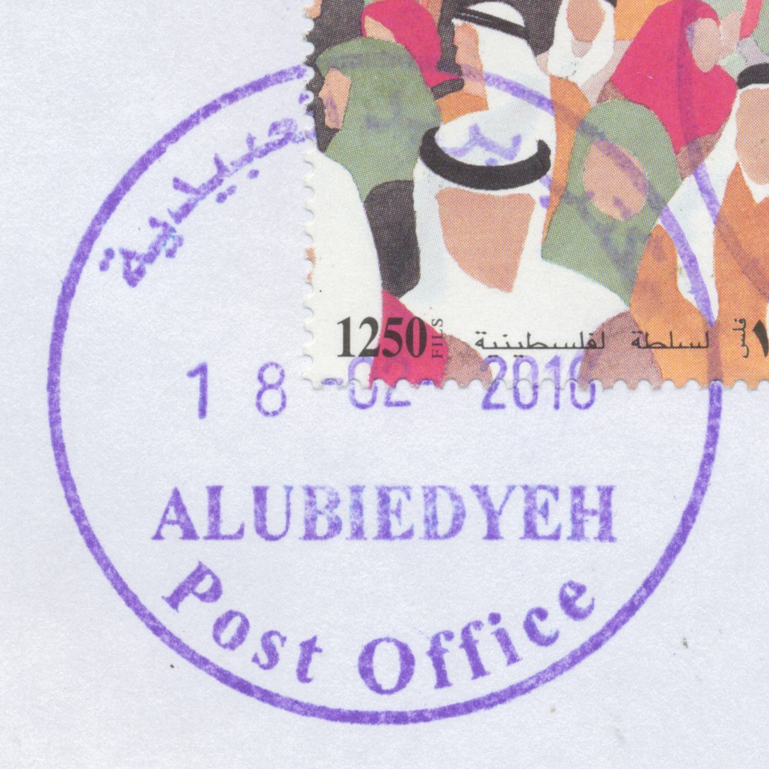
 Al 'Ubeidiya © OpenStreetMap contributors, CC-BY-SA") | Al 'Ubeidiya العبيدية Al 'Ubeidiya, al-Ubeidiya, al-Obaidya, Al Ubeidiya, Alubiedyeh | Pop.: 10,753 Govern.: Bet Opened: 2005 PO Number: 505 Postcode: 184 | |||||||||
| 31°43' N, 35°17' E OpenStreetMap Google Maps Wikipedia | Town in Bethelehem Governorate about 9 km NE of the muhfaza with 10,753 residents in the 2007 Census (1997: 6,257). Beit Sahur, Za'tara & al-Aizariya are the neearest other post offices. The office is, together with the libary in municipaliy buildings (town hall) on main street. Jordanian authorities operated a postal agency between 30.09.1965 and 4.06.1967. | ||||||||||
| |||||||||||
 ubeidiyaPO_160218_0501")
Special Handstamps and Cachets
| NC | Place Inscription |
Type | Gov. Size |
|---|---|---|---|
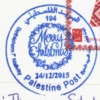
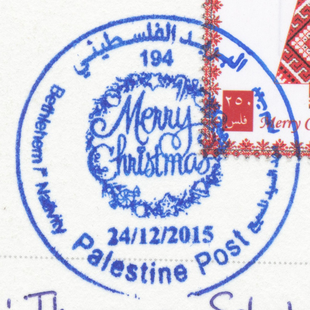
| 835 | البريـد الفلسـطيني / بيت لحم / مهد السيد المسيح / Merry / Christmas / Palestine Post / Bethlehem /* Nativity / 24/12/2015 / 194 | VI b | 37.70 |
 | |||
[20.07.2016]
[www.zobbel.de – Dipl.-Bibl.(FH) Tobias Zywietz – all rights reserved]
Imprint/Impressum – Datenschutzerklärung/Privacy Policy